SATMET Services
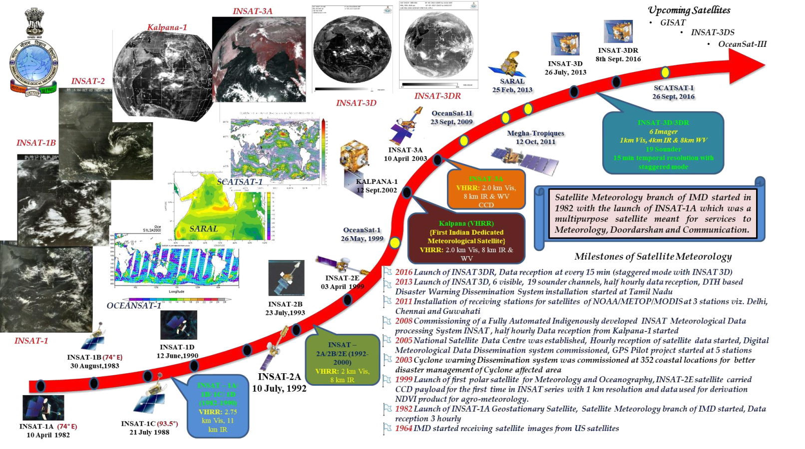
History
Satellite Meteorology Division started functioning in India Meteorological Department since early 70’s. From 1972 to 1982, IMD used to receive the Satellite imageries of NOAA and NASA meteorological satellites through SDUC and images were printed on photographic paper for using in weather forecasting.
The Indian National Satellite (INSAT) programme a series of multipurpose geo-stationary satellites by ISRO to satisfy the telecommunications, broadcasting, meteorology, and search and rescue operations started in 1982. INSAT is one of the largest domestic communication satellite systems in Asia-Pacific region with nine operational communication satellites placed in Geo-stationary orbit. It is a joint venture of the Department of Space, Department of Telecommunications, India Meteorological Department, All India Radio and Doordarshan. The first successful INSAT-1B satellite data receiving and processing system was established in 1983 in IMD as a full-flashed satellite Meteorological Division for providing satellite Metrological services to the nation. INSAT-1 series of satellites were Multipurpose satellites, having a meteorological payload, two channels Very High-Resolution Radiometer (VHRR) for imaging the Earth in Visible (0.55-0.75 µm) and Infra-Red (10.5-12.5µm) channels having resolution of 2.75 X 2.75 kms in visible and 11 X 11 kms in IR channel. Since the launching of INSAT-2 series of satellites, the spatial resolution of VHRR enhanced to 2 X 2 kms in visible and 8 X 8 kms in IR channel. In INSAT-2E satellite VHRR payload also added Water vapour (5.7-7.1µm) channel having resolution 8X8 kms along with new payload, charged couple device (CCD) of three channels (Visible -0.62 to 0.69µm), Near Infra-Red 0.77 to 0.86µm) and Short Wave Infra-Red 1.55 to 1.77µm) bands, having a resolution of 1KM. During both INSAT-1 and INSAT-2 series, the temporal resolution of scan acquisitions was 3 hourly. Since 1996, the satellite imageries were opened for public through IMD website. A dedicated meteorological satellite, Kalpana-1 was launched on 12th September, 2002 carrying VHRR payload and multipurpose INSAT-3A satellite was launched on 10th April, 2003 carrying VHRR and CCD payloads along with communication transponders. The temporal resolution of scan acquisitions by Kalpana-1 was 3 hourly with 3 triplet (00,06,12 UTC) during 2002 – 2005, hourly with 3 triplet (00,06,12 UTC) during 2005 – 2008 and Half Hourly during 2008-17. The temporal resolution of scan acquisitions by INSAT-3A, VHRR payload was 3 Hourly (2003 – 2008) and then Hourly (2008-16). The CCD payload used to take acquisitions six times during day (03,05,06,07,09 &11 UTC). Both INSAT-3A and Kalpana-1 had been decommissioned and discontinued since September 2016 and September 2017 respectively.
The division has made a steady progress in satellite data reception and generation of several new products which are quite useful in weather forecasting and the division now plays an important role in supporting weather forecasting.
Current Status
At present, there are two operational meteorological satellites; INSAT-3D & INSAT-3DR carrying 6 channel imager for imaging the earth in visible (0.55-0.75um),SWIR (1.55-1.70um) of resolution 1KmX1 Km, MIR (3.80-4.00um),TIR-1 (10.30-11.30um),TIR-2(11.50-12.50um) of resolution 4KmX4Km and WV (6.50-7.10um) of resolution 8KmX 8Km. and 19 channel sounder consisting of 7 channels of LWIR (14.71-12.02um), 5 channels of MWIR (11.03-6.51um), 6 channels of SWIR (4.572-3.74um) and one channel of visible (0.695um) each of resolution 10X10 Km scan the atmosphere for derivation of profiles. INSAT-3D was launched on 26th July, 2013 and located at 82 degree east and INSAT-3DR was launched on 08th September 2016 and is located at 74 degree east. At Present 48 nos. of satellite passes are acquired daily from each INSAT-3D and INSAT-3DR IMAGER payload, are being used in stager mode so that after every fifteen minutes a new set of images/ product become available to the forecasters. The INSAT-3D and INSAT-3DR sounder scans are acquired on every 60 minutes for sector A (Indian land region) and every 90 minutes for sector B (Indian Ocean region) respectively, with inter-changing their scan areas between Sector A and B after every three-hour interval to get temperature and humidity profiles of these regions. The qualitative products generated after processing the satellite data are disseminated to users for use in Weather forecasting. In addition to these both satellites are having Data Relay Transponder (DRT) payloads which are being used to receive and transmit the data from Automatic Weather Stations (AWS)/ Automatic Rain Gauge (ARG) network of different institutions from all over India.
Functions of the Division
- A dedicated Earth station used to receive data directly from operational INSAT series of Geostationary satellites namely INSAT-3D and INSAT-3DR. Data received from these satellites is processed in INSAT Meteorological Data Processing (IMDPS) system and generates imageries of all channels and quantitative products such as Cloud Motion Vector (CMV), Water Vapour Wind (WVW), visible/ mid-infrared wind, Wind derived products (Vorticity, Shear, Shear Tendency, Convergence & Divergence) Outgoing Long Wave Radiation (OLR), Quantitative Precipitation Estimates namely Hydro Estimator (HE), INSAT Multispectral Rain fall, Algorithm(IMSRA) and GPI/QPE, Sea Surface Temperature (SST) and Upper Tropospheric Humidity (UTH), Night time fog, Snow cover, Aerosol Optical Depth (AOD), Fire, Smoke, Land surface Temperature (LST), upper Tropospheric Humidity(UTH), Insolation, temperature and humidity profile, total ozone layer precipitable water/total precipitable water.
- INSAT -3D and INSAT-3DR satellite data are used in forecasting / monitoring weather.
- The radiance values and satellite derived wind of INSAT-3D are provided to NCMRWF for its assimilation in NWP model. Wind products are transmitted on GTS in BUFR format. All the imageries and derived product are disseminated on website on real time basis.
- Round the clock surveillance of weather systems including severe weather events around the Indian region and generating satellite bulletins based on satellite images and products for use in forecasting.
- Detect genesis and growth of tropical cyclones their location and intensity at required intervals depending upon its severity. Monitor movements of migrating systems such as tropical cyclones, troughs/ridges, jet streams, region of intense convection, Inter tropical convergence zone etc.
- Various satellite products such as OLR, Wind speed over sea and Water Vapour over sea etc. are given as an input to weather forecasters and used to decide the onset of monsoon.
- Development and operationalization of Real-time Analysis of Product and Information Dissemination (RAPID) in IMD.
- Generation and dissemination of T-phi gram at district level from Satellite data.
- All the processed Satellite images & products are archived on a regular basis.
- A network of 25 Nos Global Navigation Satellite System (GNSS) to derive Integrated Precipitable Water Vapor (IPWV) at the interval of 15minutes is operational which are made available to forecasters through website as monitoring of IPWV provide a guidance for nowcasting the weather and data generated by GNSS network is assimilated in NWP models.
- NOAA/MODIS/ METOP Satellite data receiving and processing system at New Delhi, Chennai and Guwahati are used to receive and process the data of NOAA, METOP-A, Terra, Aqua and FY1 polar orbiting Satellites and derived level-1, level-2 products and profiles are made available to forecasters through website for users.
- Provide satellite meteorology planning inputs to WMO/CGMS and other National and International agencies.
Click Here for further details